


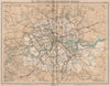

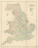

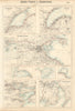

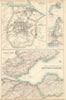
A British cartographer who came from a celebrated line of mapmakers. As holder of a royal warrant he used the title "Cartographer to the King". His most enduring legacy may be the naming the continent of Antarctica, hitherto largely ignored. He introduced the use of colored contour layer maps. He was an early publisher of city street maps, cycling maps, railway timetable maps & road maps for motorists. He set out the first edition of the Times Survey Atlas of the World, published posthumously. Our stock includes maps from the "Handy Reference Atlas of London and Suburbs" (various editions 1913, 1917, 1921, 1925 & 1930) and the "Citizen's Atlas" (various editions 1898, 1901, 1924, 1952).
EU orders up to €150 are sent VAT- and duty-paid — no additional taxes on arrival
Authenticity Guaranteed - We only sell original antique & vintage items
Can we help? Call us on +44-208-960-3476 • FAQs
All our products are exempt from US tariffs — no additional duties or taxes payable on arrival.
- Shop by Country
- Shop by Cartographer
- Shop Maps by Type
- Shop Prints by Subject