


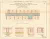

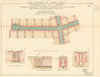
Pipes, sewers and service subways beneath the City of London are laid bare in these maps by H. Montague Bates, drawn as evidence for the Royal Commission on London Traffic and published in 1906. Contemporary directories link Henry Montague Bates with the City's public-health administration. His diagrams locate the services under Fleet Street in October 1903, Lothbury in December 1902 and the Blackfriars Bridge approach in November 1900, with sections showing how they filled the space below ground. Separate diagrams describe the subways at Holborn Viaduct, built in 1869, Arthur Street East, Edmunds Place and Lime Street Avenue.
EU orders up to €150 are sent VAT- and duty-paid — no additional taxes on arrival
Authenticity Guaranteed - We only sell original antique & vintage items
Can we help? Call us on +44-208-960-3476 • FAQs
All our products are exempt from US tariffs — no additional duties or taxes payable on arrival.


- Shop by Country
- Shop by Cartographer
- Shop Maps by Type
- Shop Prints by Subject