


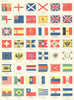
Flags, ensigns and Highland clans give these maps by W. & A. K. Johnston, the Edinburgh and London publishers, a strongly heraldic character. Late nineteenth-century atlas plates display the national flags, ensigns and royal and imperial standards of the world as they stood when the atlases appeared. A large mid-twentieth-century map of the Scottish Highlands surrounds the clan territories with tartans, arms and dress, and an early twentieth-century tourist map of Ceylon, now Sri Lanka, takes the firm far from Scotland.
EU orders up to €150 are sent VAT- and duty-paid — no additional taxes on arrival
Authenticity Guaranteed - We only sell original antique & vintage items
Can we help? Call us on +44-208-960-3476 • FAQs
All our products are exempt from US tariffs — no additional duties or taxes payable on arrival.


- Shop by Country
- Shop by Cartographer
- Shop Maps by Type
- Shop Prints by Subject