


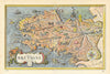


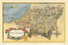


The Latin Quarter, Montmartre and the provinces of France receive a playful pictorial treatment in these maps from La France, Paris et les provinces, published by Éditions Odé in 1948 and associated with the travel writer Doré Ogrizek. The Paris maps move between the Latin Quarter, Montmartre, the islands of the Seine and the great central avenues, while László Fircsa's provincial maps range from Brittany and Normandy to the Pyrenees, Alsace, Burgundy and the Mediterranean. Wine regions, châteaux and mountain resorts are drawn into each outline, so that local character, food, wine and sightseeing carry as much of the information as the geography.
EU orders up to €150 are sent VAT- and duty-paid — no additional taxes on arrival
Authenticity Guaranteed - We only sell original antique & vintage items
Can we help? Call us on +44-208-960-3476 • FAQs
All our products are exempt from US tariffs — no additional duties or taxes payable on arrival.


- Shop by Country
- Shop by Cartographer
- Shop Maps by Type
- Shop Prints by Subject