


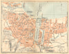

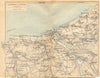
Rouen, Dieppe, Fécamp and the cliffs of the Channel coast fill these maps from Les Guides Bleus Normandie, published by Hachette in 1921 under Marcel Monmarché's direction for French travellers. Town plans of Rouen, Évreux and the smaller ports sit beside excursion sheets following the shore between Étretat and Fécamp or around Le Tréport. Made after the First World War and before the later destruction and rebuilding of many Norman towns, the plans are valuable for locating older streets and buildings.
EU orders up to €150 are sent VAT- and duty-paid — no additional taxes on arrival
Authenticity Guaranteed - We only sell original antique & vintage items
Can we help? Call us on +44-208-960-3476 • FAQs
All our products are exempt from US tariffs — no additional duties or taxes payable on arrival.


- Shop by Country
- Shop by Cartographer
- Shop Maps by Type
- Shop Prints by Subject