


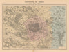




Departmental maps framed by vignettes of their chief towns, from Le Mans and Poitiers to Orléans, distinguish the Nouvel Atlas Illustré La France et ses colonies, published in Paris by Direction et Administration between 1890 and 1903. The cartography is by MM. Vuillemin, Thuilier, Ch. Lacoste and Lorsignol, with illustrations by M. Fillatreau. Metropolitan departments include Sarthe, Seine-et-Marne, Vienne, Yonne, Cher, Doubs, Drôme, Eure, Gard and Loiret, while overseas maps cover Algeria with its provinces of Constantine, Algiers and Oran, Tunisia, Indochina, Martinique, Guadeloupe, French Guiana, the French possessions in India, New Caledonia and Polynesia, alongside world maps.
EU orders up to €150 are sent VAT- and duty-paid — no additional taxes on arrival
Authenticity Guaranteed - We only sell original antique & vintage items
Can we help? Call us on +44-208-960-3476 • FAQs
All our products are exempt from US tariffs — no additional duties or taxes payable on arrival.


- Shop by Country
- Shop by Cartographer
- Shop Maps by Type
- Shop Prints by Subject