


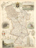


Ornamental borders frame hand-coloured county outlines in these maps from The English counties in the nineteenth century, associated with Thomas Moule and published in London by George Virtue. The sheets date from about 1840, when railways were entering a landscape still organised around county towns, estates and older roads, and the early lines can be followed within the county boundaries alongside the established settlements. English shires predominate, with separate coverage for places such as the Isle of Wight, the Isle of Thanet and Yorkshire's East Riding, and the decoration gives them an appearance quite different from a plain survey sheet.
EU orders up to €150 are sent VAT- and duty-paid — no additional taxes on arrival
Authenticity Guaranteed - We only sell original antique & vintage items
Can we help? Call us on +44-208-960-3476 • FAQs
All our products are exempt from US tariffs — no additional duties or taxes payable on arrival.


- Shop by Country
- Shop by Cartographer
- Shop Maps by Type
- Shop Prints by Subject