


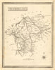


England and Wales in 1864, when the railway had become central to travel but coach roads still mattered, are mapped county by county in The Travelling Atlas of England & Wales. John Heywood published the atlas in Manchester, a reminder that practical map publishing flourished beyond London. English counties from Cornwall, Cumberland and Northumberland to Middlesex and the Midlands are joined by regional maps of north and south Wales, and cities, towns, parks and country seats give travellers further points of reference along the routes.
EU orders up to €150 are sent VAT- and duty-paid — no additional taxes on arrival
Authenticity Guaranteed - We only sell original antique & vintage items
Can we help? Call us on +44-208-960-3476 • FAQs
All our products are exempt from US tariffs — no additional duties or taxes payable on arrival.


- Shop by Country
- Shop by Cartographer
- Shop Maps by Type
- Shop Prints by Subject