


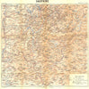


City streets, Alpine valleys and the vineyards of the Côte d'Or are mapped with precision by Louis Thuillier, the French cartographer credited on maps for Hachette's guidebooks. Thuillier (1848–1919) drew detailed plans of Bordeaux, Toulouse, Poitiers, Clermont-Ferrand and other cities, from the late nineteenth century into later editions. Regional sheets turn to the Auvergne, the Alps, the Pyrenees and the western coast, bringing relief and travel routes into view, and a Côte d'Or wine map adds specialised vineyard geography. His drawing credit sits within a process that also involved engravers and printers.
EU orders up to €150 are sent VAT- and duty-paid — no additional taxes on arrival
Authenticity Guaranteed - We only sell original antique & vintage items
Can we help? Call us on +44-208-960-3476 • FAQs
All our products are exempt from US tariffs — no additional duties or taxes payable on arrival.


- Shop by Country
- Shop by Cartographer
- Shop Maps by Type
- Shop Prints by Subject