
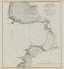

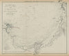

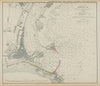

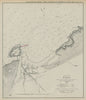


Breakwaters that were planned for Douglas, Peel, Port Erin and St Ives are drawn over the surveyed bays in these mid-Victorian harbour charts attributed to Captain G. Williams. Published in 1859, they cover the three Manx harbours, surveyed with Evans, and St Ives Bay in Cornwall. Each sheet sets the proposed works against the existing coastline and its approaches, combining hydrographic observation with engineering, and a comparative sheet places Douglas and St Ives side by side.
EU orders up to €150 are sent VAT- and duty-paid — no additional taxes on arrival
Authenticity Guaranteed - We only sell original antique & vintage items
Can we help? Call us on +44-208-960-3476 • FAQs
All our products are exempt from US tariffs — no additional duties or taxes payable on arrival.


- Shop by Country
- Shop by Cartographer
- Shop Maps by Type
- Shop Prints by Subject