


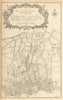


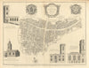

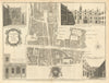


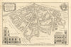


City wards, parish boundaries and the Bank of England appear in these prints from Maitland's History and Survey of London, taken from the third edition printed for T. Osborne in London in 1760. William Maitland's history was illustrated with plans and views credited to makers including Benjamin Cole, William Henry Toms and Emanuel Bowen. Ward maps record parishes, precincts and City jurisdictions, and wider plans extend to Westminster and the country around London. The architectural plates show churches, hospitals, palaces, bridges and the House of Commons, while retrospective maps show earlier London, the Civil War fortifications and the plans made after the Great Fire.
EU orders up to €150 are sent VAT- and duty-paid — no additional taxes on arrival
Authenticity Guaranteed - We only sell original antique & vintage items
Can we help? Call us on +44-208-960-3476 • FAQs
All our products are exempt from US tariffs — no additional duties or taxes payable on arrival.


- Shop by Country
- Shop by Cartographer
- Shop Maps by Type
- Shop Prints by Subject