


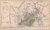


Victorian commerce at full stretch, from the mapped streets of Manchester and Birmingham to the Thames and Medway estuaries, fills these maps and prints from The Imperial Gazetteer of England & Wales, published by A. Fullarton. The material here, from 1865, combines city plans, harbour mapping and engraved prospects that illustrated the gazetteer's descriptions of places, and John Bartholomew's name appears on the cartography. Milford Haven and the estuaries show the waterways of trade and naval activity, while the views include London seen from Southwark and Liverpool across the Mersey, dense with building and shipping.
EU orders up to €150 are sent VAT- and duty-paid — no additional taxes on arrival
Authenticity Guaranteed - We only sell original antique & vintage items
Can we help? Call us on +44-208-960-3476 • FAQs
All our products are exempt from US tariffs — no additional duties or taxes payable on arrival.


- Shop by Country
- Shop by Cartographer
- Shop Maps by Type
- Shop Prints by Subject