
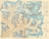
Erwin Hermann Manfred Schneider (1906-1987) was an Austrian mountaineer, cartographer and alpine photographer, known for his important contributions to high-altitude mountain topographic cartography. He was the official cartographer for the Deutscher Alpenverein and a member of the Österreichischer Alpenverein, under whose auspices he participated in expeditions and was responsible for the creation of detailed maps of the Andes and Himalayas. He created the highest quality and largest-scale maps produced to date of parts of Nepal - the so-called "Schneider maps", which many experts consider to be unrivalled in the world in their depiction of extreme high mountain landscapes. In particular, high-quality maps of the Khumbus and the mountains around Mount Everest were created based on triangulation and terrestrial photogrammetry fieldwork undertaken by Schneider during the 1955 International Himalaya Expedition. The map was described in the "History of Cartography" as "a masterpiece of reconnaissance surveying". Schneider was a pioneer in the use of terrestrial photogrammetry in the use of mountain cartography, in which photographs taken from multiple known locations are used to calculate distances, elevations, and contours with high accuracy.
EU orders up to €150 are sent VAT- and duty-paid — no additional taxes on arrival
Authenticity Guaranteed - We only sell original antique & vintage items
Can we help? Call us on +44-208-960-3476 • FAQs
All our products are exempt from US tariffs — no additional duties or taxes payable on arrival.
- Shop by Country
- Shop by Cartographer
- Shop Maps by Type
- Shop Prints by Subject